Map 34 – Sydenham – Kemble Wetland

Map 34 – Sydenham – Kemble Wetland Jul. 15, 2019 | Map 34, Edition 29 An expansive 316 acres of BTC preserved land has been decorated with a new trail system taking 1.9 km off of Concession 20 and Cole’s…
Map 34 – Sydenham – Kemble Wetland Jul. 15, 2019 | Map 34, Edition 29 An expansive 316 acres of BTC preserved land has been decorated with a new trail system taking 1.9 km off of Concession 20 and Cole’s…
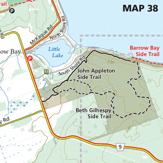
Map 38 – Peninsula – Barrow Bay Cliffs Jul. 12, 2019 | Map 38, Edition 29 A new trail network has been established on the Bruce Trail Conservancy’s newly acquired Barrow Bay Cliffs Nature Reserve, including a new side trail…
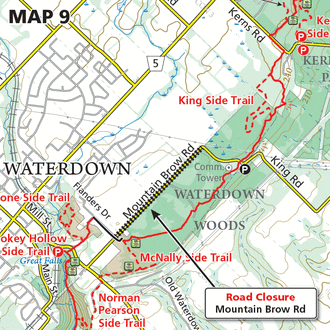
Map 9 – Iroquoia – Road Closure Jul. 2, 2019 | Map 9, Edition 29 Mountain Brow Rd between King Rd and Flanders Dr is permanently closed as of June 10, 2019 Please see this link for more information. As a result,…
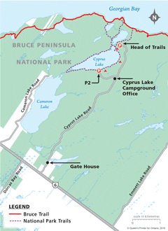
Map 42 – Peninsula – Bruce Peninsula National Park, Access for through-hiking BTC Members Date Effective: Jun. 20, 2019 | Map 42, Edition 29 Access for Through-Hiking BTC Members at Bruce Peninsula National Park’s Head of Trails Thanks to an…

Map 11 – Toronto – Sixth Line Jun. 18, 2019 | Map 11, Edition 29 At the request of the landowner, the location of the Bruce Trail has been moved. Decommissioned trail = 530 metres New main Trail = 485…

Map 18 – Caledon Hills – Vineyard View Side Trail Jun. 8, 2019 | Map 18, Edition 29 This dead end trail leads up a hill to a viewpoint overlooking the vineyards of the Adamo Estate Winery. Vineyard View Side…

Map 14 – Caledon Hills – Cheltenham Badlands – Creditview Rd parking May. 13, 2019 | Map 14, Edition 29 Roadside parking is no longer permitted on Creditview Road south of Olde Baseline Rd. Parking fines are being issued.
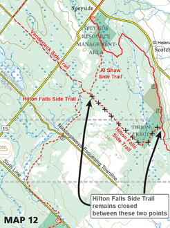
Map 12 – Toronto – Hilton Falls Side Trail closure Apr. 30, 2019 | Map 12, Edition 29 The map above denotes the current trail status of this area with a portion of the Hilton Falls Side Trail remaining closing…

Map 1 – Niagara – General Brock Side Trail Apr. 26, 2019 | Map 1, Edition 29 The map above displays how a portion of the General Brock Side Trail has been rerouted. Decommissioned route = 650 metres New route…

Map 25 – Beaver Valley – Recommended Parking Apr. 1, 2019 | Map 25, Edition 29 The roadside parking found directly north of km 27.0 on 10th Line is no longer a recommended parking location. The Town of Blue Mountains…