International Friendship Trails
International Friendship Trails and the Bruce Trail Conservancy
The Bruce Trail is one of many wonderful footpaths worldwide.
As a founding member of the World Trails Network, the Bruce Trail Conservancy is working with international trail organizations to raise awareness of and support for public footpaths through the creation of Friendship Trails.
Friendship Trails are similar to twin towns, whereby trail organizations in different countries team up in the name of partnership, mutual publicity and international cooperation.
The Bruce Trail Conservancy currently has 9 Friendship Trails. In each case, a route on the Bruce Trail (Main and side trails) and a corresponding route on the international trail have been designated as a Friendship Trail, displaying special signs to mark the partnership.
Connecting the World of Trails
The Bruce Trail Conservancy is a proud member of the World Trails Network.
The World Trails Network brings trail associations, trail advocates, enthusiasts and professionals together from around the world to foster global collaboration and networking for the betterment of the world’s trails.
Friendship Trail Badge Series
By hiking the Friendship Trail route on the Bruce Trail and on the corresponding twinned portion on the international trail, you can earn badges! Once you have completed both sections, contact the Bruce Trail Conservancy and we will send you the Friendship Trail badge and corresponding trail badge, at no cost.

The Rim of Africa Trail Friendship Trail – Niagara Club
A section of the Bruce Trail in the Niagara Club is twinned with a section of the Rim of Africa Trail. Below is a map of the Rim of Africa Friendship Trail on the Bruce Trail. You’ll also find it on our Bruce Trail Reference Map 3.
The Rim of Africa is a unique mountain passage trail and conservation initiative at the southern edge of Africa in the Cape mountains. These mountains form the core of the Cape Floristic Region, the smallest of the six recognised floral kingdoms of the world, an area of extraordinarily high diversity and endemism, and home to more than 9 000 plant species, the greatest non-tropical concentration of higher plant species in the world.
At its core the Rim of Africa initiative offers a hiking experience through a series of linked high mountain traverses, some involve easy path-hiking, while others are off-path and require confident mountain and hiking skills. The entire route is 52 days in duration and can be walked in a variety of ways.
The Rim of Africa mission is to help preserve and protect the natural beauty of these mountains and the important ecosystem functions they offer communities living along the route.
Rim of Africa is a mountain initiative with community, conservation and hiking at its heart.


-300x71.png)
Mountains to Sea Greenway Friendship Trail – Iroquoia Club
The official opening for this Friendship Trail will took place in September 2024.
This section of the Bruce Trail is twinned with the Tefuye Historical Trail of the Mountains to Sea Greenway (MSTW) in Taiwan.
Located in southwestern Taiwan, MSTW is a 177 km long-distance hike from Yanshuei River estuary to Mt. Jade, the highest peak in East Asia, at 3,952 meters above sea level. It spans across several forest biomes and aquatic ecosystems at different altitudes. It also links up Han culture, and Austronesian peoples such as Siraya, Tsou, and Bunun, making it a window into the cultural richness of Taiwan.
Tefuye Historical Trail (MSTW 26) is 6.4 km long. The route was initially a hunting path used by the Tsou people. During the Japanese colonial rule (1895-1945), the Japanese built a railway along this historical trail to transport red cypress and Taiwan cypress logged in the Alishan area. Now there are remains of the old railway and wooden bridges along the trail. The blueprint of the MSTW began in 2007 as a grassroots river protection project, and in 2018, the forestry bureau, along with 13 government agencies along the MSTW, and Taiwan Thousand Miles Trail Association (TMI Trail) formed a cross-sector/inter-municipal collaboration to jointly promote and maintain the MSTW.
You can find an English guidebook to the Mountains to Sea Greenway here.


Kythera Trails Friendship Trail – Toronto Club
In May 2017, a section of the Bruce Trail in the Toronto Club was twinned with Kythera Trails in Greece. Below is a map of the Kythera Trails Friendship Trail located in the Toronto Club. You’ll also find it on our Bruce Trail Reference Map 11 and Map 12.
Kythera lies between Greece and Crete, and is an island jewel in the Greek seas. A rough diamond spared from mass tourism, Kythera’s rugged terrain boasts immense ecological diversity. There is no better way to explore Kythera than by walking. Kythera Trails is currently comprised of twelve hiking routes that guide visitors through age-old paths, scenic spots, waterfalls, ravines, medieval villages and secluded shores. The Bruce Trail is twinned with Kythera Trail M41 – Valley of the Watermills.


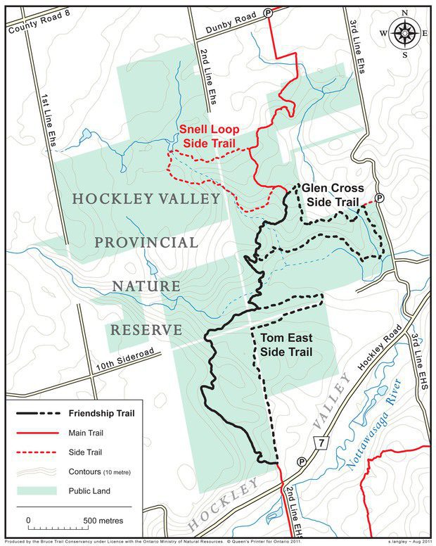
The Jeju Olle Friendship Trail – Caledon Hills Club
In September 2011, a section of the Bruce Trail in the Hockley Valley was twinned with Route 2 on the Jeju Olle. Below is a map of the Jeju Olle Friendship Trail on the Bruce Trail, located in the Caledon Hills Club, Map 18.
The Jeju Olle walking trail is located on the beautiful island of Jeju, South Korea. Jeju Island is located 130 kilometers south of the Korean Peninsula. It is a large volcanic island, almost sub-tropical in climate, with incredible scenery from the coastline through orange groves crisscrossed by distinctive stone walls and up to the peak of an inactive volcano. The Jeju Olle is the most popular walking trail in Korea, and provides over 200km of pathways, and plans are underway to extend the trail to encircle the entire island in the coming years.


Bibbulmun Track Friendship Trail – Dufferin Hi-Land
In May 2016, a section of the Bruce Trail in the Dufferin Hi-Land was twinned with the Bibbulmun Track in Australia. Below is a map of the Bibbulmun Track Friendship Trail on the Bruce Trail.
You’ll also find it on our Bruce Trail Reference Map 20.
The Bibbulmun Track opened its section of our Friendship Trail, from Balingup to Donnelly River Village, on November 1, 2015. If you are interested in more information or trip planning, please follow this link https://www.bibbulmuntrack.org.au/contact/ or https://www.bibbulmuntrack.org.au/walk-the-track/guided-tours/ or
https://www.bibbulmuntrack.org.au/walk-the-track/guided-tours/town-to-town-tours/
The Bibbulmun Track in Western Australia stretches 1000 kilometres from Kalamunda in the Perth Hills to the historic town of Albany on the south coast.
From karri forest to coastal heathlands the Track traverses some of the most beautiful and wild areas of the south west of Australia which is one of the world’s biodiversity hotspots.
Passing through nine rural towns and many popular scenic spots, walkers can enjoy day walks and the hospitality of local accommodation or embark on a six to eight week hike from end-to-end
The Track is for walkers only with 49 campsites spaced a day’s walk apart. Each campsite has a three-sided timber shelter, dunny (toilet), rainwater tank, picnic tables and tent sites.


Transcarioca Trail Friendship Trail – Blue Mountains Club
In October 2016, a section of the Bruce Trail in the Blue Mountains Club was twinned with the Transcarioca Trail in Brazil. Below is a map of the Transcarioca Trail Friendship Trail located in the Blue Mountains Club – Map 22
The 180 km Transcarioca Trail crosses Rio de Janeiro from Barra de Guaratiba to Morro da Urca, at the foot of the Sugar Loaf Mountain. The Transcarioca Trail strengthens the conservation and restoration of green corridors linking the main areas of Atlantic Forest in Rio de Janeiro. The trail offers hikers opportunities to enjoy little-known natural attractions and uncover wonderful views over Rio de Janeiro. Hundreds of volunteers believe and support the realization of this great project.


The Pacific Slope (Sendero Pacifico) Friendship Trail – Beaver Valley Club
In June 2015, a section of the Bruce Trail in the Beaver Valley is twinned with a piece of the Pacific Slope Trail in Costa Rica. The Pacific Slope Trail (Sendero Pacífico) Friendship Trail follows the Bruce Trail between Hoggs Falls (km 63.3, Map 26) to the BTC’s parking lot at km 70.1 (Map 26) taking in a portion of
the Beaver Valley’s beautiful Falling Waters landscape. Below is a map of the Pacific Slope Friendship Trail on the Bruce Trail.
The Pacific Slope Trail (Sendero Pacífico) section twinned with the Bruce Trail begins at San Luis in the famous Monteverde Cloud Forest conservation region, and the new Friendship Trail will lead into the Children’s Eternal Rain Forest by agreement with the Monteverde Conservation League.
The Pacific Slope Trail Network is a vision shared by an informal association of individuals, community groups, and some organizations who wish to link forests and rural communities along Costa Rica’s Pacific Slope via a freely accessible trail system.
Like the BTC, the Sendero Pacifico depends heavily on the participation and energy of many self-organized volunteers. The trail encompasses a network of trail systems, huts, conservation properties, ecological agriculture initiatives, alternative energy and wastewater treatment and water conservation projects.


The Lebanon Mountain Trail Friendship Trail – Sydenham Club
The Lebanon Mountain Trail Friendship Trail – Sydenham Club
In September 2012, a section of the Bruce Trail at the Bayview Escarpment Nature Reserve was twinned with section 5 of the Lebanon Mountain Trail. Below is a map of the Lebanon Mountain Trail Friendship Trail on the Bruce Trail, located in the Sydenham Club, Map 30.
The Lebanon Mountain Trail (LMT) is the first long-distance hiking trail in Lebanon. The LMT is 470 km (293 miles) in length and showcases the natural beauty and cultural wealth found among Lebanon’s mountains. It is home to 3 protected areas, 2 biosphere reserves and 1 World Heritage Site. The mandate of the LMT Association is to protect and promote the LMT for future generations.


The Cotswold Way Friendship Trail – Peninsula Club
In September 2012, a section of the Bruce Trail at the Lion’s Head Provincial Park was twinned with a section of the Cotswold Way, located in England. Due to Trail changes in the provincial park, the Friendship Trail was moved in 2023 to the Bruce Trail Conservancy’s Barrow Bay Nature Reserve in the Peninsula section. Below is a map of the Friendship Trail on the Bruce Trail located in the Peninsula Club, Map 37.
The Cotswold Way is a 102 mile National Trail in the west of England stretching between the beautiful market town of Chipping Campden in the north and the World Heritage Site of Bath in the south. This iconic walk leads you along the Cotswold Escarpment, giving you a taste of all that makes this area special. From stunning bluebell woods to open grassland with breathtaking views, through sleepy villages to thriving market towns, the Cotswold Way touches on unique variety of experience and earns its reputation of one of the world’s finest walks.
Click on the following link for the Cotswold Way Friendship Trail map in England.


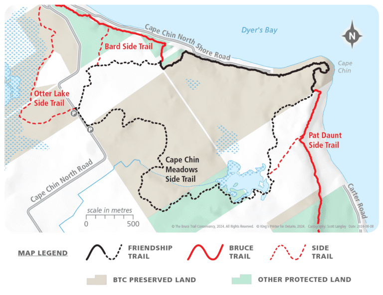
The South West Coast Path Friendship Trail – Peninsula Club
In September 2024, a section of the Bruce Trail at the Bruce Trail Conservancy’s MapleCross Nature Reserve at Cape Chin was paired with the South West Coast Path, located in England.
The South West Coast Path, the longest established National Trail in the UK, stretches 630 miles along the southern coastline from Somerset through Cornwall into Devon and Dorset, ending at Poole Harbour. Known for its spectacular coastal views, rocky cliffs, and diverse flora, it pairs beautifully with the Bruce Trail in the Peninsula section, which boasts similar features along Georgian Bay. The Friendship Trail is twinned with a section of the South West Coast Path that runs from the old fishing village of Cawsand in Cornwall, along the Plymouth city waterfront and the Devon coast to Wembury.