Map 5 – Niagara / Iroquoia – Beamer Memorial Conservation Area
Date Effective: Apr. 10, 2026 | Map 5, Edition 31
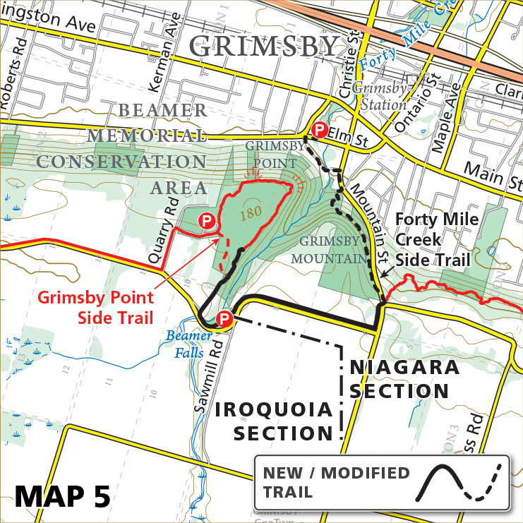
UPDATE, Apr. 12, 2026
Due to a damaged staircase in Beamer Memorial Conservation Area, a reroute and a few trail modifications have taken place.
Forty Mile Creek Side Trail has been extended to the intersection of Mountain Street and Ridge Road East (following the former route of the main Bruce Trail).
The main Bruce Trail has been re-routed along Mountain Street to Ridge Road West, along Ridge Road West to Beamer Memorial Conservation Area parking, then along the route of the former Beamer Falls Side Trail.
The boundary between the Niagara and Iroquoia sections of the Bruce Trail has been moved to Ridge Road West, at the parking area of Beamer Memorial Conservation Area.
New distances:
Forty Mile Creek Side Trail = 1.5 km
New Main Trail (solid black line shown on map) = 1.9 km
(Beamer Falls Side Trail has been converted to Main Trail).
Note: Accessible only from Gibson Street, a short stretch of the former route of the Bruce Trail remains open between Forty Mile Creek Side Trail and the damaged staircase as an in-and-out trail within the Conservation Area, but it is not currently part of the Bruce Trail network (and is not displayed on the map).
_______________________________
ORIGINAL POST, Apr. 10, 2026
A section of the main Bruce Trail at Beamer Memorial Conservation Area in Grimsby, is closed between Mountain Street and Beamers Falls Side Trail due to a damaged staircase.
A reroute of the Trail is underway and this notice will be updated when it is complete.