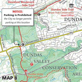
Iroquoia

Map 8 – Iroquoia – Ray Lowes Side Trail

Map 8 – Iroquoia – Ray Lowes Side Trail Dec. 6, 2021 | Map 8, Edition 30 Named for one of the co-founders of the Bruce Trail and lifelong conservationist, Ray Lowes, this side trail has taken on a new…

Map 8 – Iroquoia – Tiffany Falls, one hour parking

Map 8 – Iroquoia – Tiffany Falls, one hour parking Mar. 26, 2021 | Map 8, Edition 30 Due to high visitation, the Hamilton Conservation Authority has limited parking at Tiffany Falls Conservation Area to one hour.

Map 8 – Iroquoia – Restricted Access, RBG Arboretum

Map 8 – Iroquoia – Restricted Access, RBG Arboretum Dec. 7, 2020 | Map 8, Edition 30 Access to the Royal Botanical Gardens Arboretum from York Rd via the Ray Lowes Side Trail is currently restricted.  The Arboretum trails are…

Map 9 – Iroquoia – Parking reestablished, Guelph Line

Map 9 – Iroquoia – Parking reestablished, Guelph Line Dec. 7, 2020 | Map 9, Edition 30 Roadside parking has been reestablished at this location. Park within the designated area between the two No Parking signs. 

Map 8 – Iroquoia – Reroute, Canterbury Falls

Map 8 – Iroquoia – Reroute, Canterbury Falls Oct. 28, 2020 | Map 8, Edition 30 The generosity of a landowner granting permission to have the Bruce Trail on their land has allowed for a new trail configuration to appear.…

Map 9 – Iroquoia – Fisher’s Pond Nature Reserve

Map 9 – Iroquoia – Fisher’s Pond Nature Reserve Sep. 16, 2019 | Map 9, Edition 29 Following the recent acquisition of the Fisher’s Pond Nature Reserve, the main Bruce Trail has been rerouted to the east side of the…

Please Consider Making a Donation

$
One-Time Gift