Blue Mountain Resort
Explore the Escarpment
Self-Guided Bruce Trail Hikes
The Bruce Trail Conservancy is
proud to welcome you to Canada’s
oldest and longest marked footpath.
For over 60 years, the Bruce Trail has connected people with nature and inspired them to work together to protect and restore the Niagara Escarpment, a UNESCO World Biosphere and one of the most biodiverse regions in North America. The Main Trail runs 900 kilometres from Queenston in Niagara to Tobermory on the Bruce Peninsula. Along the way, there are nearly 500 kilometres of side trails that lead to waterfalls, incredible vistas, geological features and more. The Bruce Trail Conservancy is one of Ontario’s largest land trusts, a leading Canadian conservation charity, and steward of this world-class trail network that attracts to over 1 million visitors annually.
During your time at Blue Mountain Resort, you have the opportunity to explore an interesting, beautiful and unique section of the Bruce Trail. With input from our local volunteers, we’ve developed four self-guided hiking routes to help you explore the Niagara Escarpment. As you prepare to set out on your adventure, there are a few things you should know before you go.
Bruce Trail Users’ Code
Visiting the Bruce Trail can be a fun and enriching experience. To ensure everyone enjoys their time on the Trail and to that our relationships with the people, animals, and plants that live along the Trail remain strong, be sure to follow the Bruce Trail Users’ Code:
1. Hike only along marked routes. Do not take short cuts.
2. Obey all signage.
3. Use the stiles. Do not climb fences.
4. Respect the privacy of people living along the Trail.
5. Leave the Trail cleaner than you found it. Carry out all litter.
6. No open fires are allowed on the Trail. Use a portable stove.
7. Camp only at designated camp sites.
8. Leave flowers and plants for others to enjoy. Do not damage live trees or remove bark.
9. Where dogs are permitted, keep dogs on a leash and under control at all times.
10. Do not disturb or feed wildlife and farm animals.
11. Keep the Bruce Trail a welcoming and inclusive space by respecting the experience of other Trail users.
12. Leave only your thanks and take nothing but photographs.
Follow the Bruce Trail Blazes
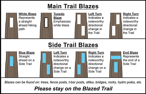
Staying on the marked trail will ensure that you remain safe, sensitive vegetation is not damaged, and relationships with private landowners along the Bruce Trail are not strained.
To stay on the Bruce Trail follow the blazes. The Bruce Trail is marked with painted rectangles – blazes – to guide hikers. Look for these rectangles on trees, posts, rocks and wooden steps for passing over fences.
When in doubt, follow the blazes. If the blazes don’t match your map, always follow the blazes. If you lose the Trail, go back to the place where a blaze was last seen.
If you walk more than about 20 metres without seeing a blaze, you’re probably not on the Bruce Trail. When this happens, turn around and retrace your steps, until you reach a place that has blazes.
Self-Guided Hikes Along the Bruce Trail
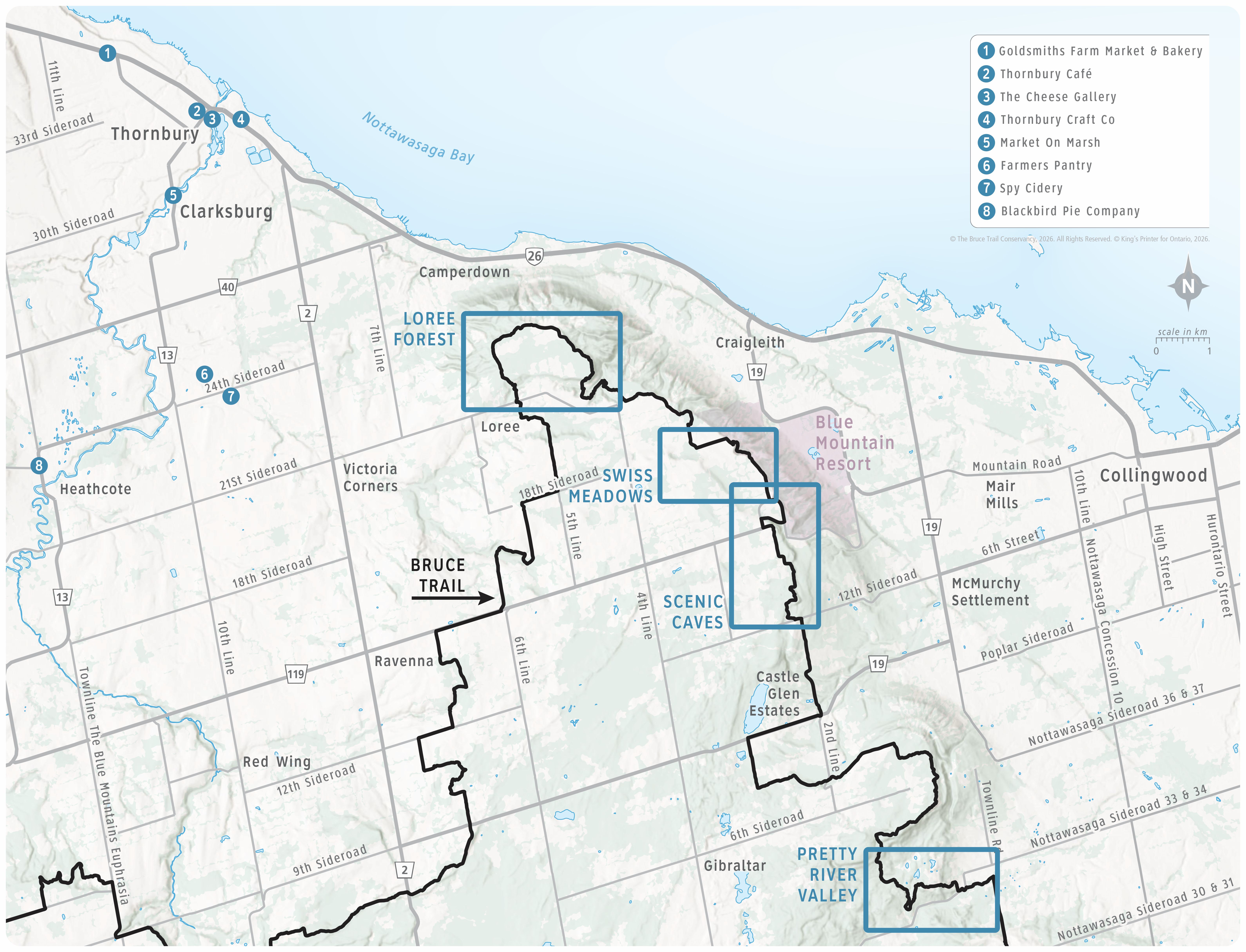
Below you’ll find an overview map of the four hike opportunities along the Bruce Trail, as well as the locations for other participating businesses and organizations as part of your Explore the Escarpment Package. Each of the four hikes has its own map below, which we encourage you to download or screenshot ahead of your journey. Happy hiking!
Terrain Guide:
Easy: Mostly flat and usually good footing.
Moderate: Some hills and/or some poor footing.
Strenuous: Hilly with steep climbs and some poor footing.
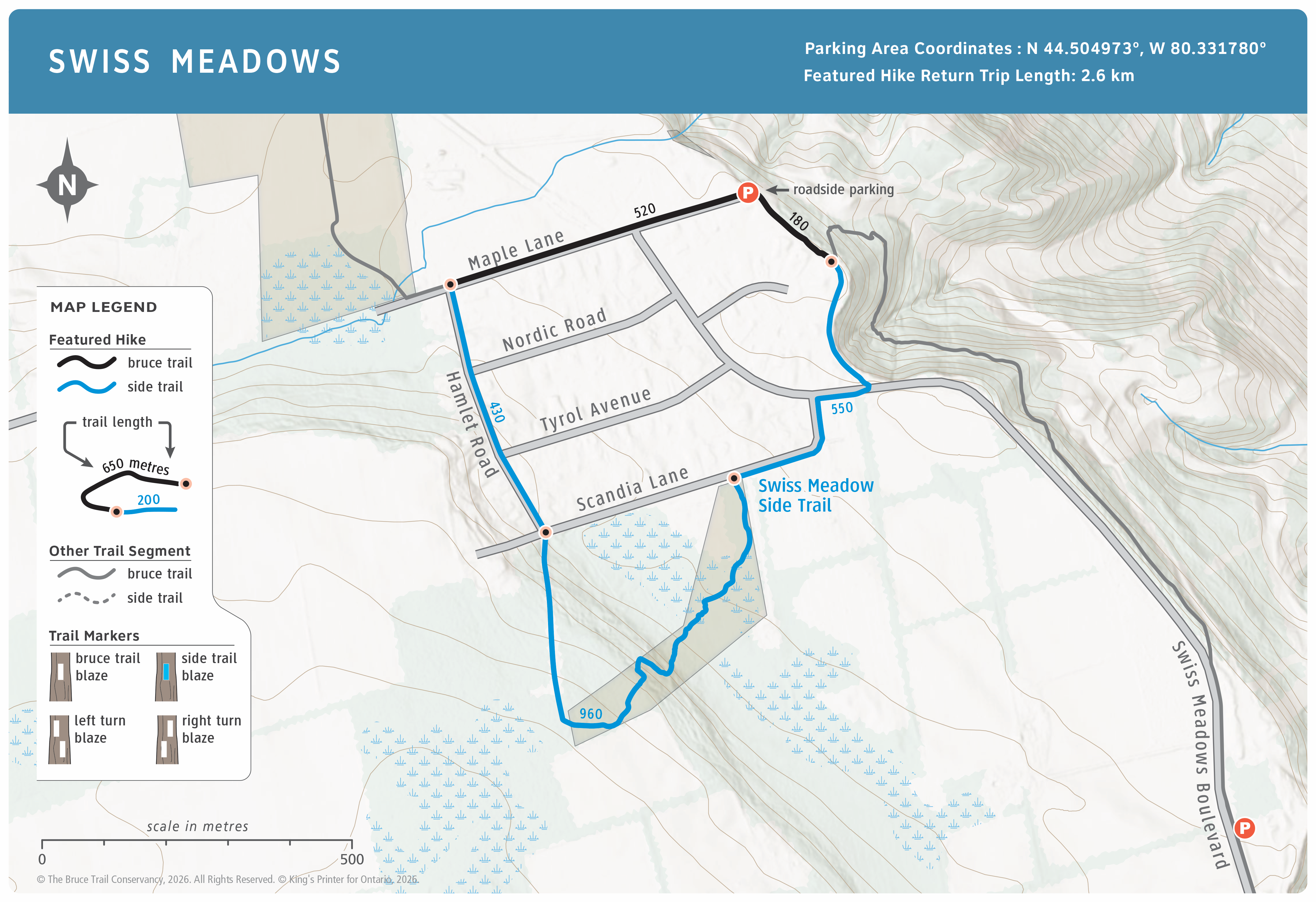
Swiss Meadows Hike
Details:
Hike Length: 2.6 km
Terrain: Easy
Parking: Roadside on Maple Lane
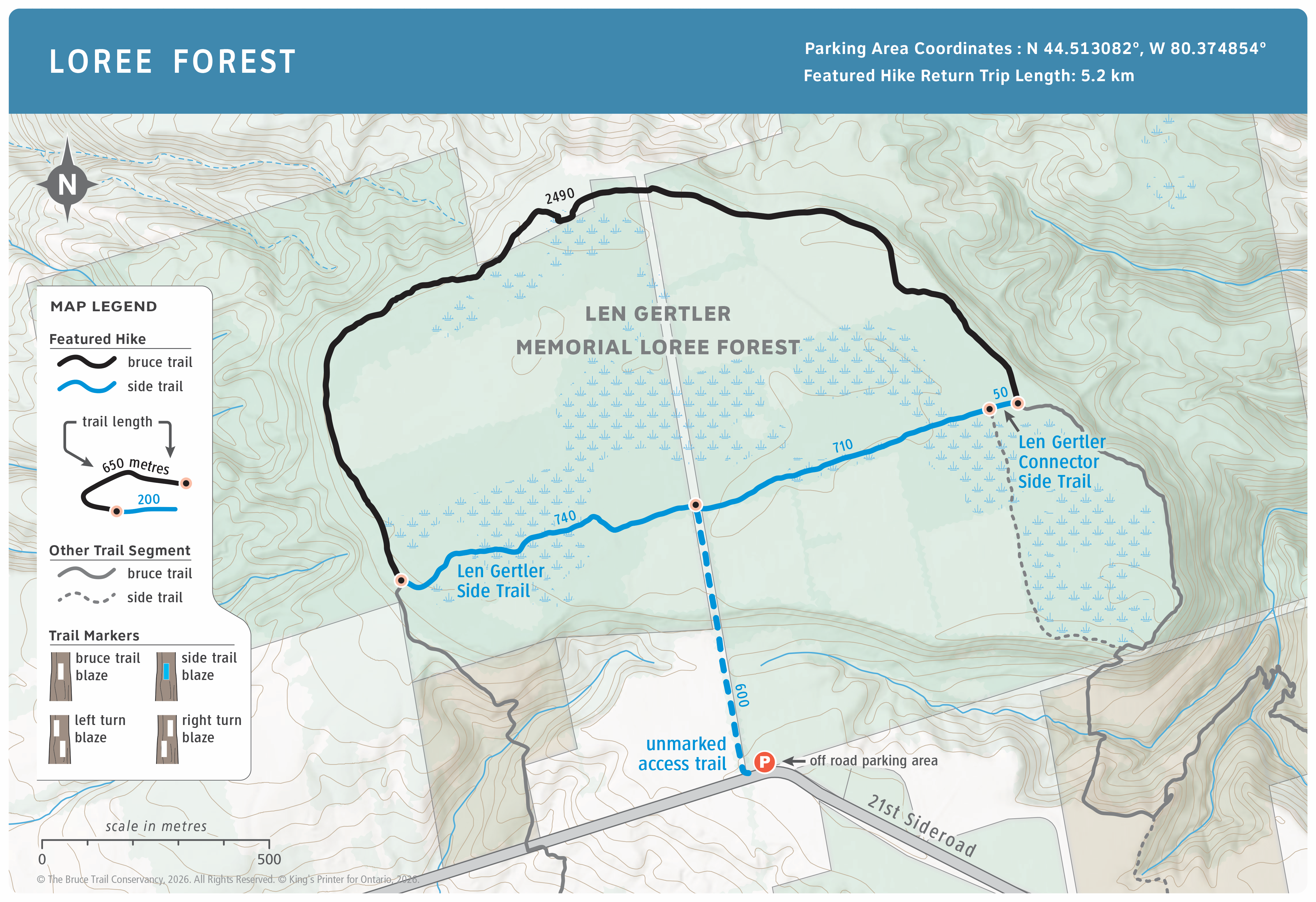
Loree Forest Hike
Details:
Hike Length: 5.2 km
Terrain: Moderate
Parking: Off road on 21st Sideroad
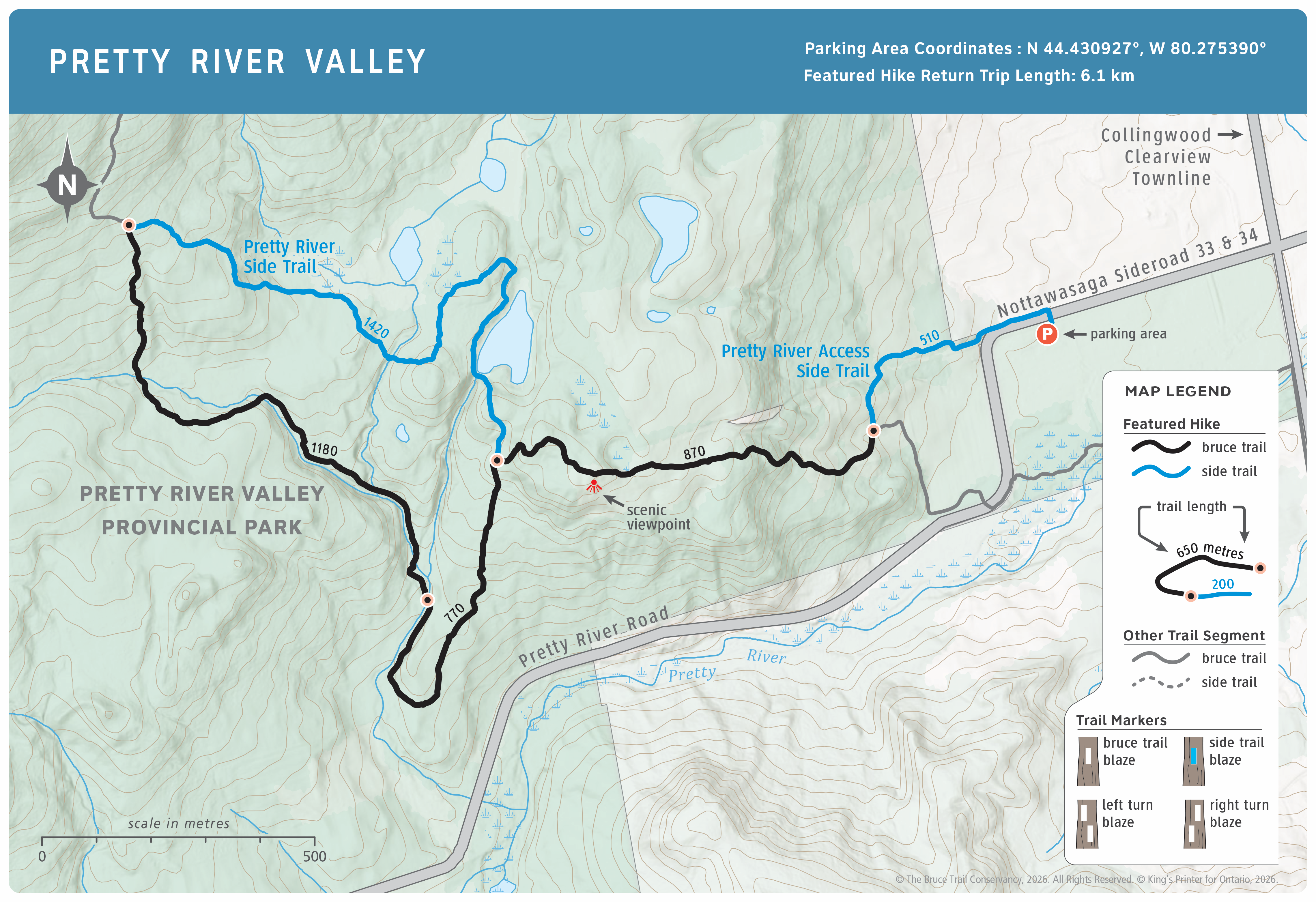
Pretty River Valley Hike
Details:
Hike Length: 6.1 km
Terrain: Strenuous
Parking: Area on south side of Nottawasaga Sideroad 33 & 34
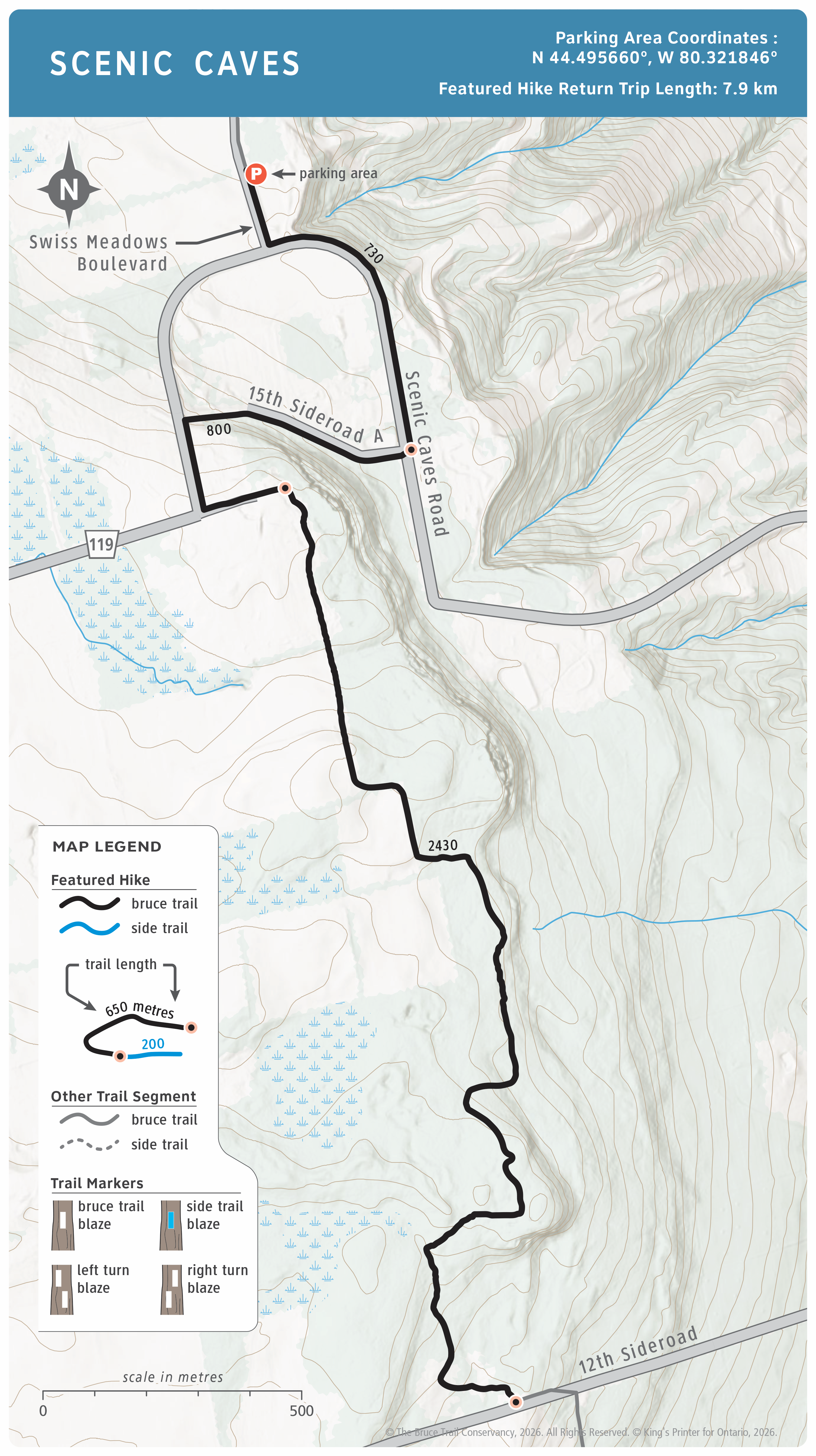
Scenic Caves Hike
Details:
Hike Length: 7.9 km in and out combined.
Terrain: Easy
Parking: On Swiss Meadows Blvd.